Gisborne District Council is one step closer to returning land at Tokomaru Bay to its rightful owner, having issued a letter of intent.
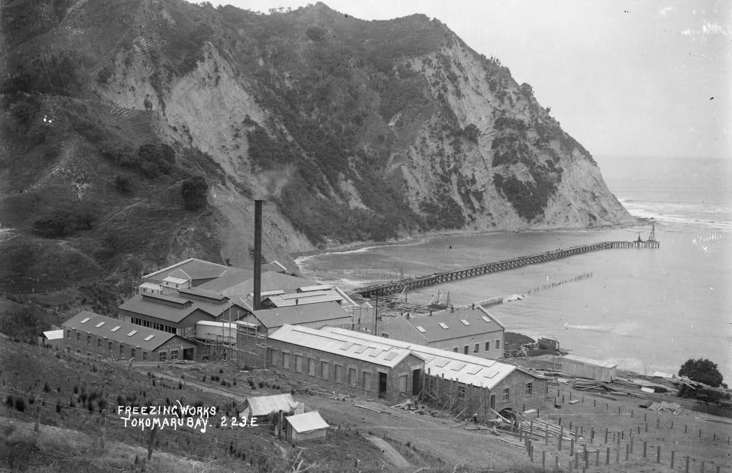
Much of the land at Tokomaru Bay (pictured here in the early 20th century) was acquired by entities which were later amalgamated into the Gisborne District Council. Photo: Alexander Turnbull Library / Supplied
In September, Nga Hapū o Tokomaru Ākau - comprising neighbouring hapū Te Whānau o Te Aotawarirangi and Te Whānau a Ruataupare - presented to council seeking a return of the land which had been taken for harbour purposes around the time of World War I.
On Thursday, a number of councillors spoke out in favour of a statement of intent to pursue the return of the land, with deputy mayor Josh Wharehinga saying it was the right thing to do.
"There are lots of conversations happening both in-region and around the country about what a good treaty partner looks like. This is what it looks like whānau. We are making a principled decision to give the land back," he said.
Wharehinga added that it wasn't the council's decision who the land was returned to, despite the issue being raised with the council by a specific party.
That decision would ultimately be made by the High Court later this year, with several applicant groups seeking customary marine title and protected customary rights at Tokomaru Bay.
Speaking to Local Democracy Reporting, Nga Hapū o Tokomaru Ākau representative Roger Tichborne said the history of the area had been hidden while it remained under council control.
Tichborne said it wasn't until the mayorship of John Clarke that the "archives were opened" for the first time, but researching was a painful exercise.
"You take for example our grandfathers going away and serving in the trenches in the First World War. And that's the period when it was taken.
"Tokomaru is rich in history, but it's hidden. It's locked away. I want to bring forth the sacred history of Tokomaru Bay."
Nga Hapū o Tokomaru Ākau representative Roger Tichborne Photo: Supplied
For Tichborne, the memory was particularly painful because part of the land belonged to his grandfather.
"The 191 acres was taken by the Harbour Board, for what purposes no one knew. It's been sitting in the council for over 100 years. Just sitting there."
But he said he was buoyed by the response of councillors at the December meeting, many of whom questioned the council's holding of the land in the first place.
Background on the land provided by Darrell Naden - a solicitor representing Nga Hapū o Tokomaru Ākau - paints an upsetting picture for Māori.
In the early 1900s, trade was increasing across the region, culminating in developments in Tokomaru Bay which included a new wharf, and a freezing works in 1911.
The Māori land owners of the site where the freezing works was built were given their payment in shares, which only provided a temporary benefit considering the operation closed down in 1952.
In 1914, land parcels were taken to widen the road to the freezing works and wharf, with the ancestral meeting house Te Poho-o-Te-Aotawarirangi being moved to make way for it.
In 1916, the foreshore, which is a strip between the high and low water marks, was surveyed with a certificate of title issued to the Harbour Board.
The total area was about 191 acres between Te Mawhai and Koutunui Point, which was essentially all of Tokomaru Bay.
The board was an entity controlled by the Waiapu County Council, but it is unclear why they needed the whole of Tokomaru Bay.
In 1916, further Māori-owned land was compulsorily acquired and vested in the Harbour Board, including steep slopes overlooking the wharf. Again, it is not clear why this section was needed for harbour purposes.
Another strip of land was taken the following year, running from Te Koau to the boundary of the Tawhiti land, with no compensation paid.
Much of the land was acquired while Māori were fighting for New Zealand at Gallipoli and on the western front.
The land came under Gisborne District Council's control in 1989, by way of the amalgamation of other councils in the region.
The council currently holds titles spanning the entirety of Tokomaru Bay's shoreline.

Local Democracy Reporting is Public Interest Journalism funded through NZ On Air